
4: Mapping projects
(NOTE: this page will build slowly, as I have to retrieve some samples from offline external disks.)
I have been fascinated by maps since I was a young teen. Maybe Arthur Ransome’s ‘Swallows and Amazons’ books are to blame! Unfortunately I don’t have images of some of the older interesting projects I have worked on.
My mapping projects have been undertaken to fulfil a number of different purposes:
- As straight cartography, to introduce an audience to a territory with which they were unfamiliar (this was certainly true of my work for East Timor).
- To present statistical information in map form (choropleths etc).
- To direct people to find a location through street maps (wayshowing. especially for conference locations).
- To function as a base in educational multimedia presentations and documentary videos where the ‘story’ unfolds in a geographical space.
East Timor, mapping in solidarity (1976)
In November 1975, the Revolutionary Front for Independent East Timor (FRETILIN) declared independence for the eastern half of the island of Timor, which had been ruled by Portugal since the 16th century. Eleven days later, Indonesia (supported diplomatically by the USA and Australia) invaded and occupied the territory and a violent war of resistance began.
At the time I was in London and working for ETWRC, the Europe/Third World Research Centre, and I joined the British Campaign for Independent East Timor (BCIET). I contributed by managing our newsletter and by designing posters, badges and a small travelling exhibition.
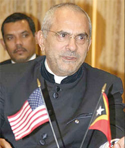
José Ramos-Horta, President of East Timor from 2007 to 2012, who ‘commissioned’ the map project to assist him in pleading the cause of his country at the United Nations.
We learned from East Timor’s representative at the United Nations, José Ramos-Horta, that there was a desperate need for a map to show a largely ignorant world where the territory of East Timor was and to give as much detail as possible about its geography, landscape etc. A problem was that Portugal, for whom the Timor situation was an embarrassment, had declared all maps of East Timor to be a ‘state secret’.
At the time, I had a library card for the London School of Oriental and African Studies (SOAS). In the map section, I found a beautiful big map of East Timor. I spent about two weeks down there, with large sheets of polyester draughting film, tracing off the coastlines, rivers, contours at 500 metre intervals, and all of the villages, using technical pens.
I then converted this map data into pre-separated overlay art for map printing, using large amounts of Letratone shading film to render the seas, and the contour gradations. For day after day I had my nose very close to dot patterns and it did funny things to my eyes… When the six-colour artwork was finished, I handed it over to our German colleague Detlev from the Ost Timors Solidaritätskomitee. He was a printing apprentice and used his access to an A2 press to print the maps in two parts. These were then carefully glued together and José received about 500 maps to hand out to delegations at the United Nations in New York. I am pretty sure this was a breach of copyright law, but other matters were more pressing.
I did get to see the finished product but for some reason I never had my own copy, otherwise perhaps I could show you… Ah well. It’s the only commission I have had from someone who later became his country’s President.
InfoDesign 2000 conference wayfinding map (2000)
Wayfinding map for the InfoDesign 2000 conference in Coventry.
:
I’ve been associated with the Information Design Association
since it got started in the UK in the early ’nineties and I have also been involved
in planning for and running several of the international conferences. This has
involved such things as setting up and running the event Web sites and creating
wayfinding maps for the several venues.
This particular event, InfoDesign 2000, was held in Coventry which is a real challenge to navigate (and to map) due to its convoluted motorway-style ringway (shown here with major feed roads in yellow). My task was to create a one-page PDF to help people to get between the station and the various venues, some of which routes required negotiating subways beneath the road junctions.
The general principle which I use is to represent the areas between the roads as shaded objects and the roads show up white as the gaps between them. This draws your eye to the roads and also keeps the road names legible.
I don’t think we lost anyone…
(Click here to see an enlarged detail view of the path from the railway station to the hotel and conference site.